|
Zanjan
province
Situated
in north -west Iran, Zanjan province has an area of 25382 square
kilometers. Being generally mountainous and hilly, it is divided into thee
regions with different climates. Takht_e_Soleiman, Taie ghan, Alamout, and
kooh-e-Rostam are the most important mountains in the province. At a
distance of 140 kilometers from the south-west of Zanjan city, in the
south of Garmab village, lies a very tightly cave called Katale Khor .the
rivers such as Ghesel Ozan, Abhar-Rood and Shah Rood flowing from
Mountains through the province create much vegetation in it. Among the
natural resources of this province, there are six hot springs and four
mineral springs in which tourists are highly interested. Because of the
medicinal value, these springs attract a large number of people each year.
The vegetation of the province varies from one area to another, but it is
generally made up of forests and pastures. The forests are mainly located
in the mountainous regions adjacent to Gilan province.
Different climates have created an animal life rich in variety.
Various species of wild animals, native and migratory birds, and aquatic
animals attract many tourists in the seasons during which hunting is
allowed. From 25 years ago, for the preservation of wild life, a vast
district of this province, called Angooran has been proclaimed a protected
district by the Iranian organization of the Environment.
Kurds
and Shahsavans are the main peoples living in the province. Azerbaijani,
Persian, Kurdish and Tati are the languages spoken in different regions.
The predominate religion is the Shi'a branch of Islam.
There
is a highway running from Tehran to Zanjan city (the capital of the
province). The main roads and even the side roads to different places of
the province are asphalted and equipped with traffic signs. In addition to
the tens of buses transporting passengers, there are regular flights
between Tehran and Zanjan.
Covering
this province and linking it with Tabriz and Europe on the one hand, and
with Tehran and other cities on the other, "the Trans-Iranian Railway
Network " transports passengers from Tehran and Tabriz by express
trains every day .due to man enfold Rivers and underground waters as well
as many pastures, agriculture and animal husbandry enjoys considerable
growth and the agricultural products are of various kinds.
There
are many mines in Zanjan province providing row materials for many home
factories. Kaolin, silver, gold, cock, copper, iron, manganese, feldspar
and silicate mines are some of the mines among others, in the province.
Zanjan
province is one of country 's important industrial centers, throughout
which there are several industrial satellite towns and metal, food,
chemical, wood, weaving, constructional and mining industries.
Of
local industries of the province, particularly of Zanjan city, is knife-
making industry, the products of which are unique in delicacy and
solidity.
The
capital city of this province is Zanjan; while it’s other cities are
Abhar, Khodabandeh and Khoramdare.
|
|
|
Zanjan
Zanjan
township is 328 km. far from Tehran. Enjoying a mild weather in summer and
cold weather in winter, Zanjan is composed of two great valleys of
"Zanjan Rood" and "Sefid Rood" between which Gharavol
and Angooran mountains are located.The foundation date of Zanjan goes back
to the reign of Ardeshir Babakan and it was called "Shahin" or
"Shahan" . By passing of time, this name was changed to
Hodood-Olalam or Limits of the World, 372 AH., it is described as a
flourishing and blessed city with a very strong fortifications.
Zanjan was badly damaged due to Mongols attack but in the reign of Sultan
Mohammad Khodabandeh, Sultanieh was changed to the largest capital of
Ilkhani government and Islamic land. By the order of Oljaito, a
fortification was constructed around Sultanieh and a huge castle was build
in its midst. He built a cemetery with a high dome for himself which is
famous Khodabandeh dome. Sultanieh became one of the most important cities
of Ilkanan after Tabriz in the reign of Oljaito.
Oljaito’s cemetry was badly damaged by Taymour the lame after the fall
of Ilkhanan in 786 AH. Sultanieh was fallen into decadence in the time of
Shah Tahmas Safavid I(930-984AH.) Fathali Shah (the Ghajar King) built a
summer palace in this city.
Today, as the result of the political and administration condition of the
city and concentration of several provincial organizations, it attracts so
many population causing development of it.
The important natural, historical, and religious sights of Zanjan are as
follows:
hSeveral mineral water springs,
|
|
|
hAngooran
Protected Area,
hZolfaghari edifice,
hZanjan fortification,
hShemiran, Sansiz and Sati castles,
hGolshan and Malek caravansaries,
hOld public bathes,
hHistorical building of Rakhtshooi Khaneh (wash- house),
hSeveral historical bridges,
hHistorical caves of Galijak and Kharmaneh Sar,
hJame’Mospues of Seyed , Mirzai and Gholayr,
hImamzadeh Seyed Ibrahim |
 |
|
|
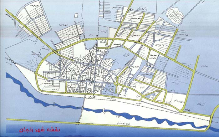
Zanjan
is administratively divided into three parts: the central part (the city
itself), and two districts outside the city called Mahneshan and
Tarom-e-olya.
This
city probably dates back to the Sassanian period. Conquered by the Muslims
in the 7th century, obliterated by the Mongols and by Tamer lane in the
13th and 14th centuries, and having a vivid record in civilization,
culture, art and sciences, Zanjan has experienced both glory and hardship.
After the Islamic revolution Zanjan has made great progress in different
fields.
|
|
|
Khoda
Bandeh
Enjoying
a mountainous climate with snowy and cold winters and mild summers,
Khodabandeh township is situated in south-east to Zanjan. In this region,
Khodabandeh-Loo and Abhar tribes have been mixed with local tribes
resulting in the appearance of a decent which is known as Zanjani decent
from apparent form point of view.Khodabandeh township encompass two
historical cities of Sohrvard and Sajas in which some knowledgeable men
like Shahabbedin Sohrvardi are brought up.
The appearance of human settlements in this region dates back to late 4th
and early 5th millennium BC.Discovered red colored earthenware is among
vestiges of this region.
The important natural, historical and religious sites of city are:
hGarmab mineral water spring
hKatleh Khoor Garmab cave,
hSajas Jame’ Mosque,
hGhaydar Nabi mausoleum,
This
town is located to the south of Zanjan, at a distance of 85 km from it.
Begin in a mountainous region; it has cold and dry winters and mild
summers. The town’s economy is based on agriculture and animal
husbandry. The shrine of Ghidar-e-Nabi is one of its sights.
|
|
|
Abhar
Enjoying
a mountainous climate with cold and snowy winters and moderate summers,
the famous river of "Abhar Rood" flows across this city.The
Abhar region, which called "Abhar Chai" (Abhar river) by native
language, is one of the oldest regions of Iran. According to existing
evidences, Abhar was more thriving in the second millennium BC. and in 9th
century BC., a union of different tribes was established in this region by
Medes.
This region became one of the important connection point coincident with
the establishment Ilkhanan government and selection of Sultanieh as
capital. The situation which even exists today.
From etymological point of view, the name of this city is derived from the
pahlavi language word of "Oher" which means the place of
controlling water flows.
The first location of the city is known as "Taphe Ghaleh" and is
in the right bank of Abhar river. This place is one of the oldest human
settlements of Zanjan province and was dwelled since early 4th millennium
BC.
The important historical and religious sights of Abhar are as follows:
hSultanieh Royal Citadel,
hHistorical hills of Said Abad-Keresf,
hDash Kasan caves,
hSultanieh dome,
hChalbi Oghli historical aggregate,
hLame’Moques of Abhar and Ghorveh,
hPirahmad Zahrnoosh and Molla Hossein Kashi mausoleums,
hSeveral Imamzadeh (shrines),
Located
in the southeast of Zanjan, in a mountainous region, this city has a mild
climate. A river called Abhar flows through the city. The river, on the
banks of which there are the relics of an ancient citadel named
Ghaleh-Tappeh, served as a natural barrier against the enemies.
Two
of the tourist attractions of city are the complex of Soltanieh and
Imam-zaadeh Esma’il of course, the former is much more important
|
|